DBF Anti-Swarm Strategic Surveillance Radar (10km UAV Detection & 500+ Target Tracking) RDX10A
Core Features:
- Unmatched 10km Detection Range: While standard radars struggle at 3km, the RDX10A-GTC extends your defense perimeter to 10km for micro-UAVs and 20km for medium targets. It provides up to 3 times more reaction time than conventional systems.
- Massive 500+ Target Tracking Capacity: Engineered for the age of “Swarm Attacks.” It can simultaneously identify and track over 500 individual targets, ensuring zero blind spots even in the most complex, high-density aerial combat or surveillance scenarios.
- Digital Beamforming (DBF) Technology: Utilizes state-of-the-art DBF technology to achieve superior spatial resolution and clutter suppression. It delivers surgical precision (Azimuth/Pitch accuracy ≤0.3°), making it the perfect guide for long-range precision neutralization systems.
- High-Speed Target Interception: Designed to track not just drones, but also cruise missiles and high-speed rotary-wing aircraft moving at speeds up to 150m/s (540km/h). It covers the full spectrum of modern low-altitude threats.
- All-Domain Air-Ground-Sea Integration: One radar for total situational awareness. From detecting a person crawling at 15kmto a vehicle at 20km, it bridges the gap between traditional air defense and ground surveillance.
Category:Product, Rader Detection
Product Details
Introduction
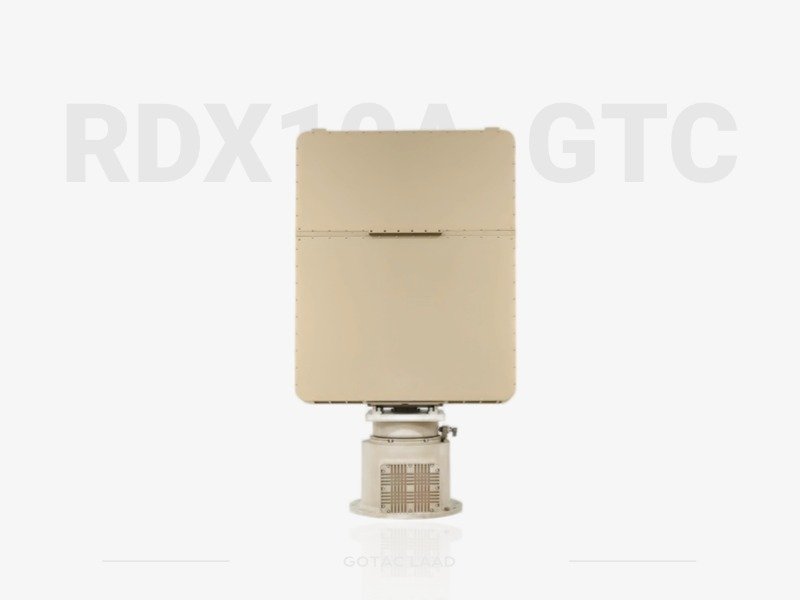
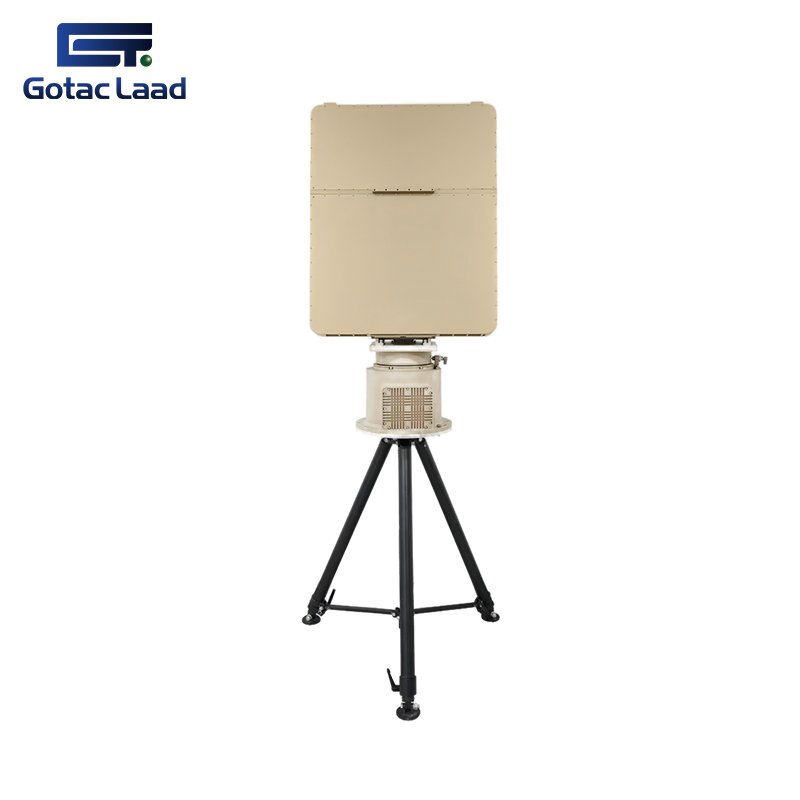
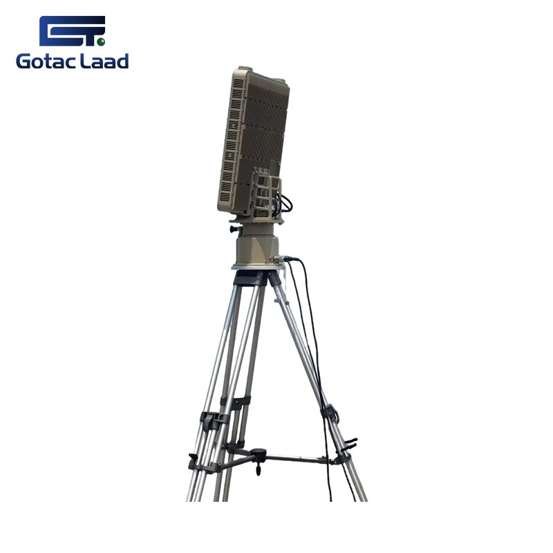
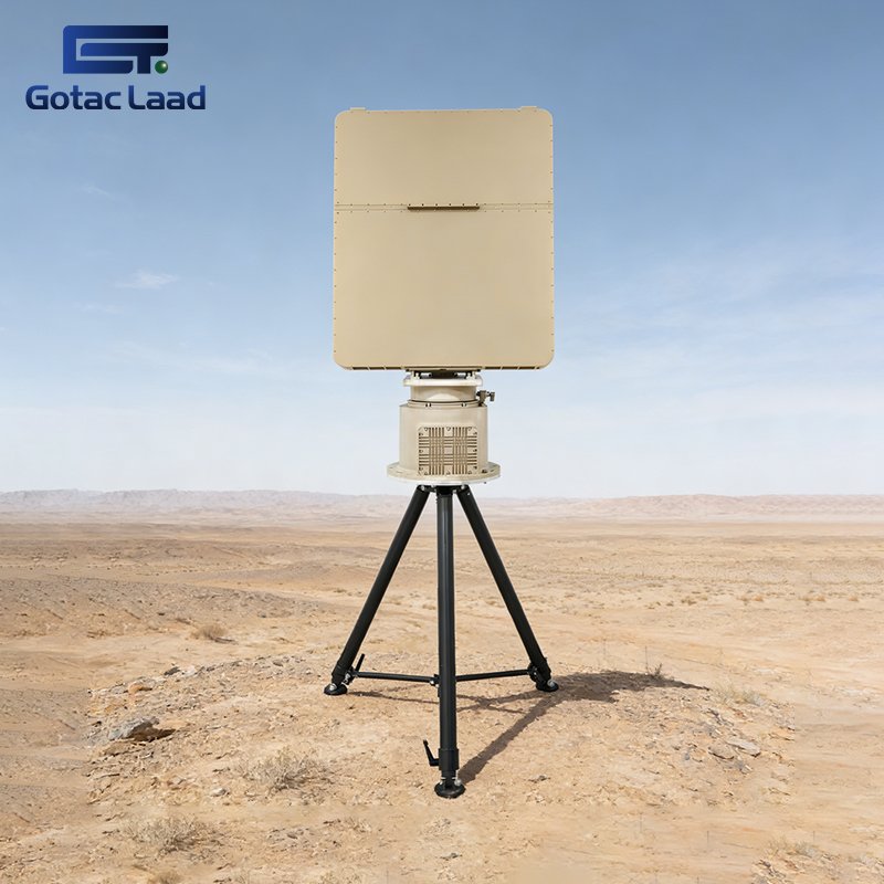
The Swarm Detection Radar RDX10A-GTC stands as the pinnacle of low-altitude surveillance technology, specifically engineered for high-stakes security environments. Integrating advanced Digital Beamforming (DBF) and a sophisticated technical architecture, it offers an unprecedented 10km detection range for micro-drones (RCS=0.01m²). This radar is not just a sensor; it is a multi-domain intelligence hub capable of tracking 500+ targets simultaneously, spanning from low-flying aircraft and cruise missiles to ground personnel and surface vessels. With its high-precision 3D data and military-grade anti-interference capabilities, the RDX10A-GTC provides the ultimate strategic advantage for border defense, airport security, and national critical infrastructure.
Parameters
| NO. | Feature | Specifications | ||
| Technical Parameters | ||||
| 1 | Operating frequency band | X | ||
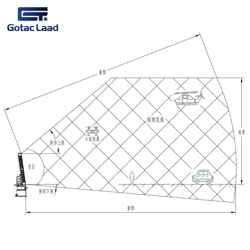
| 2 | Space coverage | Pitch | -5°~60° | |
| Position | 360° | |||
| Range | 20km | |||
| Fade zone | 50m | |||
| Height | 3000m | |||
| 3 | Detection capability | Small rotor drone(RCS=0.01m2) | ≥10km | |
| Medium-sized fixed-wing UAV(RCS=1m2) | ≥20km | |||
| Personnel | ≥15km | |||
| Helicopter, vehicle | ≥20km | |||
| 4 | Certainty of measurement | Range | ≤5m(RMS) | |
| Azimuth | ≤0.3°(RMS) | |||
| Pitch angle | ≤0.3°(RMS) | |||
| 5 | Antenna rotation speed | 20rpm(3s) | ||
| 30rpm(2s) | ||||
| 60rpm(1s) (Upgradable) | ||||
| 6 | Track target count simultaneously | ≥500 lot | ||
| 7 | Tracking speed range | 1m/s~150m/s | ||
| Interface power supply | ||||
| 1 | Power supply | DC36~52V (Equipped with an AC220V-DC48V adapter) | ||
| 2 | Communication | Gigabit Ethernet port | ||
| 3 | Power dissipation | ≤400W | ||
| Environmental suitability | ||||
| 1 | Working temperature | -40℃~+55℃ | ||
| 2 | Working humidity | ≯90% | ||
| 3 | Levels of protection | IP66 (Host IP67) | ||
| Weight and size | ||||
| 1 | Weight (kg) | Monomer | Main engine | 25 |
| Swivel table | 27 | |||
| Tripod | 20 | |||
| Package | Main engine | 45 | ||
| Swivel table | 50 (Includes all accessories such as adapters) | |||
| Tripod | 23 | |||
| 2 | Size (mm) | Monomer | Main engine | 815*650*93 |
| Swivel table | 600*500*450 | |||
| Tripod | 1100*450*450 | |||
| Package | Main engine | 970*780*250 | ||
| Swivel table | 600*520*470 | |||
| Tripod | 1100*450*450 | |||
Application scenarios
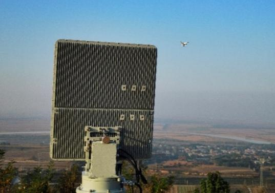
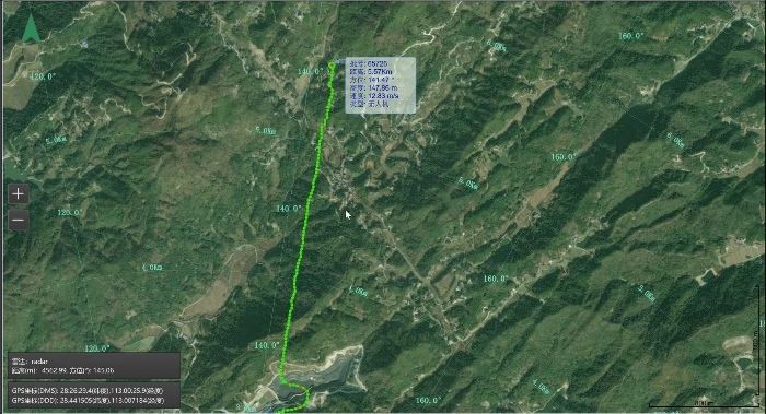
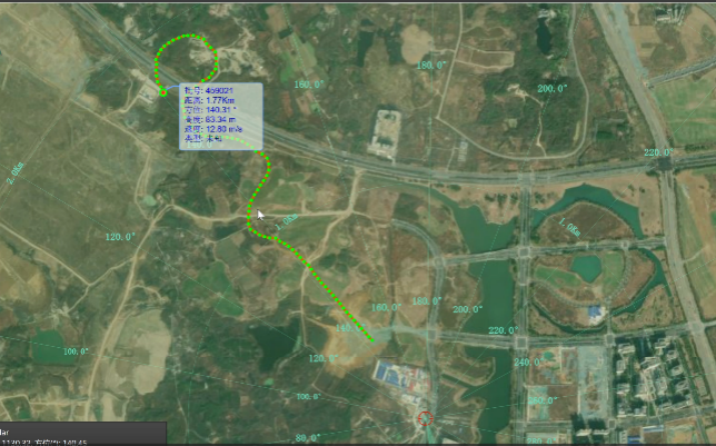
Detection and Tracking of Rotary-wing Unmanned Aerial Vehicles: Precise Positioning and Continuous Tracking for Real-time Dynamic Monitoring
 |
 |
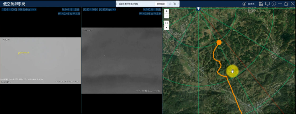
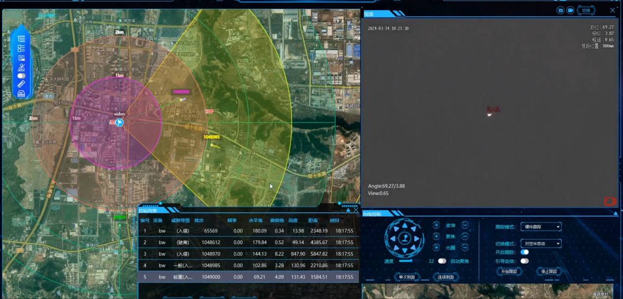
Light and Radar Collaborative Monitoring: Integrating Visible Light, Infrared, and Radar Technologies to Achieve Multi-source Data Synergy and Enhance Target Detection Accuracy
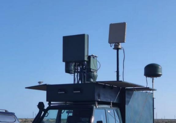
Vehicle-mounted Anti-Unmanned Aerial Vehicle (UAV) System: A dedicated vehicle platform designed to effectively counter low-altitude UAV threats and ensure regional security.
 |
 |
Airport bird monitoring: Real-time monitoring of bird activity to reduce bird strike risks and ensure flight takeoff and landing safety
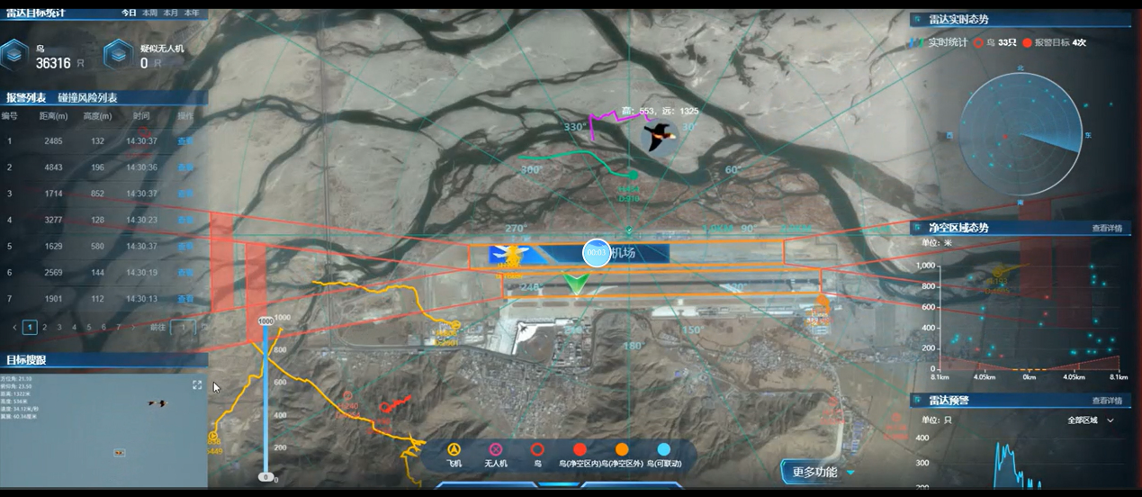
Unmanned monitoring: Integrating automated monitoring and intelligent analysis to achieve 24/7 unmanned surveillance, enhancing operational efficiency and reducing labor costs.
Frequently Asked Questions
We provide an integrated “Detect-Track-Neutralize” ecosystem. This includes high-precision microwave and millimeter-wave radar for detection and advanced laser-based neutralization for physical obstacle clearing and drone disruption.
Absolutely. Our solutions are scalable and modular, designed for seamless integration into airports, oil & gas refineries, and government facilities. We support multiple protocols to ensure compatibility with your current security management platforms.
Our hardware is industrial-grade and field-proven. Thanks to our experience in military-standard manufacturing, our systems are built to operate 24/7 in high-salt, high-humidity, and wide-temperature environments.
Yes, we offer tailored solutions based on your specific detection range and neutralization needs. As a National High-Tech Enterprise, our R&D team can provide hardware and software customization to meet local regulatory and environmental standards.